Wszystko do morskiej nawigacji elektronicznej w jednym miejscu
Wszystko do morskiej nawigacji elektronicznej w jednym miejscu

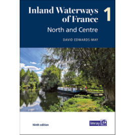
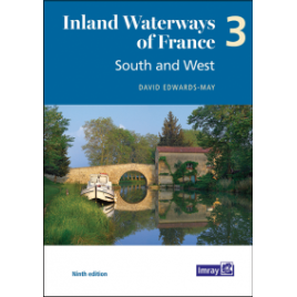
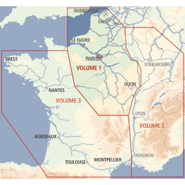
The ninth edition of Inland Waterways of France is the ideal guide for planning cruises in and through the most fascinating and diverse waterway network in Europe. This edition takes a new paperback format, split into three volumes.
 Polityka prywatności - Przeczytaj naszą politykę prywatności
 Dostawa - Przeczytaj warunki dostawy
 Zwroty - Przeczytaj warunki zwrotu towaru
David Edwards-May has investigated the many developments that have taken place during the last 10 years and presents a detailed description of the extraordinarily diverse system of navigable rivers and canals in France. With the restoration of historic navigations, the system now totals 9000 kilometres, and has become a favourite destination for tens of thousands of boaters from Europe and the rest of the world.
This volume will serve to plan ongoing or future cruises through the 2500 kilometres of waterways from the northeast – the cross-border rivers Meuse, Moselle, Sarre and Rhine – to the Mediterranean. On the busier waterways recreational use is growing alongside the commercial traffic, but there are many places where boats can moor safely. Waterways are an important part of the appeal of France as a tourist destination.
This new edition sets out the current state of the network in 126 pages in full colour, with detailed maps of 40 key sites, towns and junctions, and overview maps for each waterway. It is a unique blend of practical information, descriptions of places, maps, background historical notes and colour photographs.
Specyficzne kody
Brak ocen
The ninth edition of Inland Waterways of France is the ideal guide for planning cruises in and through the most fascinating and diverse waterway network in Europe. This edition takes a new paperback format, split into three volumes.